
Moses Lake ZIP Directory Coverage
Official city pages consistently use 98837 for Moses Lake, and the USPS location page identifies the Moses Lake Post Office in that delivery area. Research did not produce a complete live USPS city-and-state result, so the careful claim is that 98837 is the verified core ZIP, not that no other acceptable postal name or route can ever occur. The ZIP code directory separates that verified result from nearby Grant County ZIPs.
| ZIP | Verified service area | Postal office | Boundary note |
|---|---|---|---|
| 98837 | Moses Lake, Moses Lake North, and rural Moses Lake-area addresses | Moses Lake Post Office, 223 W 3rd Ave | The mailing area extends beyond incorporated Moses Lake. |
| Nearby Grant County ZIPs | 98823 Ephrata, 98824 George, 98848 Quincy, and 98851 Soap Lake | Separate community post offices | Not verified as ZIPs serving incorporated Moses Lake. |
The post office at 223 W 3rd Ave publishes 98837-9998 as its full facility ZIP+4 and lists 509-764-6701. That suffix identifies the postal facility, not a second community ZIP. For one home or business, use the USPS ZIP Code Lookup. It accepts a street address or a city and state, and it remains the official check for delivery formatting.
98837 Beyond Moses Lake
The key local geography problem is simple: a 98837 mailing address does not prove that the parcel lies inside Moses Lake. Census geography places Moses Lake North in ZCTA 98837, while county property records use labels such as “Moses Lake Rural.” The city-limit and urban growth area map draws another boundary. Postal delivery, census tabulation, and municipal authority are separate systems.
That split changes where a request goes. Moses Lake Community Development handles city permits and city GIS within the city. Grant County GIS assigns site addresses in unincorporated areas and maintains county spatial data. A parcel near the edge may use Moses Lake in its mailing address yet fall under county planning, a fire district, or another taxing area. Check the parcel jurisdiction before asking for a permit file.
Boundary check. Treat a ZIP as a delivery clue. Confirm city limits with the parcel map and the city-limit or UGA layer.
Find Moses Lake Residents by ZIP
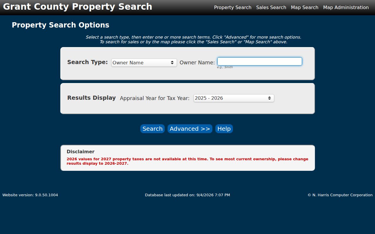
No official Moses Lake household list offers a simple public ZIP-wide browse. Build a careful result from postal verification and parcel records. PACS shows ZIP information on parcel detail, but the inspected basic search did not expose ZIP as an input. Its City field, address fields, Sales Search, and Map Search can narrow the work. Do not claim that its unverified Advanced controls include a ZIP filter.
- Enter the full street address in USPS lookup and save the standardized city, state, and ZIP result.
- Search the address in Grant County PACS. Record the situs address, owner, parcel or Geo ID, and jurisdiction clues.
- Open the city or county parcel map. Compare the parcel with city limits and the urban growth area instead of relying on the postal city.
- Use official records tied to that parcel or jurisdiction. A broad voter-file extract has legal use limits and is not a casual household directory.
Once the postal area narrows to a named road, the Moses Lake street directory gives the full by-address workflow. It also explains why the tax mailing address can differ from the property location.
Moses Lake Parcel Search Fields
PACS is useful to a ZIP code directory even without a verified ZIP input because its other fields lead to the parcel detail where mailing and situs data appear. “Situs” means the physical location of taxable land. Mailing address means where the tax notice goes, which may be a post office box or an agent.
| Search control | Use in ZIP research | Verified behavior |
|---|---|---|
| Street Number and Street Name | Find one delivery address | Optional text; partial street text is accepted |
| City | Narrow records labeled Moses Lake | Select field on the basic form |
| Property ID / Geo ID | Return to the same parcel across maps | Separate identifier fields |
| Advanced | Subdivision, township, range, and tax year | ZIP input was not verified |
| Map Search | Locate land when an address label is unclear | Separate search route |
See the live Grant County Property Search before relying on current ownership. The captured PACS screen shows the actual entry controls used to reach parcel detail.
Moses Lake ZIP Terms Explained
Postal and map labels often look interchangeable. They are not. These terms keep the Moses Lake ZIP code directory precise when a record gives only part of an address.
- ZIP code
- A five-digit USPS routing area. It is made for mail delivery, not municipal government.
- ZIP+4
- A four-digit add-on that narrows a delivery segment, building, box group, or postal facility.
- PO-box ZIP
- A ZIP assigned to post office box service. Research found no separate box-only Moses Lake ZIP to publish.
- Unique ZIP
- A ZIP assigned to one high-volume organization. No verified Moses Lake unique ZIP surfaced in the official sources.
- Carrier route
- A postal delivery path within a ZIP. It is not the same as a neighborhood or precinct.
Definitions guard against false matches. A shared five-digit ZIP can include rural tracts, a census-designated place, and incorporated blocks at the same time.
Parcel Numbers Beat Postal Drift
Grant County explains Property ID as a 16-digit key in a 6-6-4 pattern. The first six digits encode township, range, and section. The next six reflect map coordinates, and the last four distinguish the more exact description. PACS also displays a Geo ID. These database keys and a legal description remain steadier than a postal label.
A lot, block, and plat reference can bridge the map and title record. The sampled Pelican Point common-area parcel cites Pelican Point Addition No. 1 and Volume 6 of Plats, page 32. That record has a Moses Lake Rural situs and a Moses Lake 98837 post office box for the owner. It is a clear local example of why ZIP, owner mail, and parcel location must be kept in separate columns.
Note: A PACS sales row is a research lead, while the Auditor's recorded deed controls the legal transfer.
Moses Lake ZIP and City Limits
The city profile and boundary map describe Moses Lake as a municipal area with water, streets, and a separate urban growth area. ZIP 98837 follows delivery needs instead. It includes addresses whose tax detail can say Moses Lake Rural. ZCTA 98837 is yet another shape created by the Census Bureau to report statistics. A ZCTA approximates a ZIP but does not administer mail.
Use the Moses Lake city-limits and UGA map for the city line, county GIS for unincorporated land, and USPS for delivery. Road names visible near the boundary include Division, Broadway, Pioneer, Yonezawa, Wheeler, Stratford, Nelson, and Baseline. A map match should still be checked against the current parcel detail.
Addressing authority follows that same line. Grant County assigns addresses outside incorporated cities through its grid system. A road-side marker is required when a structure sits more than 100 feet from the designated road or cannot be seen from it, and the assigned number must meet the county's visibility rules. City Hall handles properties inside the city. These details help resolve a rural address that appears under more than one label.
Tax and service districts can add more names to the same parcel. The PACS detail may identify a rural tax area, school district, fire district, hospital district, library district, port, and other levy lines. Those fields explain public-service geography, but none changes the USPS delivery result. Keep the standardized postal address, parcel jurisdiction, and taxing districts in separate fields.
Older Moses Lake Address Clues
Modern ZIP codes do not organize the oldest Moses Lake records. The settlement formed as Neppel, was platted under that name in 1911, and became incorporated Moses Lake in 1938. Older directories, census pages, and papers may use Neppel, a rural precinct, a township, or only a street and telephone number.
Search an old household with the surname, street, and occupation first. Then compare a legal description or deed. A postmaster index can supply names, locations, service years, and sometimes family-name details, but it lists postmasters rather than all residents. FamilySearch's Washington Postmaster Indexes cover years before 1965 and serve as context, not a ZIP-wide roll.
Keep Nearby ZIPs Separate
Ephrata, George, Quincy, and Soap Lake have their own verified community ZIPs and post offices. Their presence in Grant County does not make them Moses Lake ZIP codes. Likewise, a service district or county office based in Ephrata may hold a record for a 98837 parcel without changing the parcel's mailing city.
The strongest method is narrow and repeatable: verify the exact delivery address with USPS, identify the parcel in PACS, check the city or county boundary map, and route the record request to the agency shown by the land's jurisdiction. This prevents a ZIP code directory search from turning nearby county geography into false Moses Lake matches.
When a city-and-state USPS search produces an unexpected result, confirm the full street address rather than assigning a nearby ZIP by distance. Postal routes follow delivery operations, not the nearest downtown or county office. A Grant County record held in Ephrata can still concern a Moses Lake parcel, and an agency address in another ZIP does not place the subject property there.
Historical work needs a second check because early records predate modern ZIP codes. Preserve Neppel, precinct, township, plat, and road variants beside the current 98837 form. The stable legal description or parcel key can reconnect those older labels after postal geography has changed.